METARs explained

METAR stands for aerodrome routine meteorological report and details the current observed weather at an airport. The weather may be observed by a human or by automated equipment. METARs are normally produced every hour but during significant changes in weather, a SPECI (aerodrome special meteorological report) will be published. METARs and SPECIs follow the same coded format.
METARs have several groups of data that follow the same order. Some groups may be omitted, but the order never changes. The order is:
- report type
- location
- date and time
- report modifier
- wind
- prevailing visibility
- runway visual range (RVR)
- variations in RVR
- present weather
- sky conditions
- temperature and dewpoint
- altimeter setting
- wind shear
- remarks
Let’s look at this example METAR and decode each group. We will only discuss how to decode a METAR, not weather theory.
METAR CYHZ 271800Z CCB 15007G15KT 3/4SM R14/4000FT/D -RA BR BKN005 OVC010 05/M05 A3014 WS RWY 14 RMK SF5NS5 VIS NW 3/8 SLP218=
Report Type:
| METAR CYHZ 271800Z CCB 15007G15KT 3/4SM R14/4000FT/D -RA BR BKN005 OVC010 05/M05 A3014 WS RWY 14 RMK SF5NS5 VIS NW 3/8 SLP218= Report type indicates the type of report, either a routine weather observation (METAR) or a special weather observation (SPECI). SPECIs are issued when the weather has changed significantly outside of the routine report. In our example, the report is a routine weather observation (METAR). |
Location:
| METAR CYHZ 271800Z CCB 15007G15KT 3/4SM R14/4000FT/D -RA BR BKN005 OVC010 05/M05 A3014 WS RWY 14 RMK SF5NS5 VIS NW 3/8 SLP218= The location of where the observation was made, normally within 3 KM of the center point of the runways. In our example, the airport is Halifax Standfield International Airport. |
Date and Time:
| METAR CYHZ 271800Z CCB 15007G15KT 3/4SM R14/4000FT/D -RA BR BKN005 OVC010 05/M05 A3014 WS RWY 14 RMK SF5NS5 VIS NW 3/8 SLP218= The first two digits indicate the day of the month followed by the time of observation in UTC or “zulu” time. In our example, the observation was made on the 27th day at 1800Z. |
Report Modifier:
| METAR CYHZ 271800Z CCB 15007G15KT 3/4SM R14/4000FT/D -RA BR BKN005 OVC010 05/M05 A3014 WS RWY 14 RMK SF5NS5 VIS NW 3/8 SLP218= There are two possible entries here. The first is AUTO, meaning the observation was done by an automated observation system, not a human observer. The second indicates if there is a correction. CCA would indicate the first correction, CCB the second, and so on through the alphabet. In our example, the METAR is its second correction. |
Wind:
| METAR CYHZ 271800Z CCB 15007G15KT 3/4SM R14/4000FT/D -RA BR BKN005 OVC010 05/M05 A3014 WS RWY 14 RMK SF5NS5 VIS NW 3/8 SLP218= The two-minute average wind direction and speed at the time of observation is used. The first three digits give the direction of the wind in true degrees, followed by the speed. In Canada and the United States, wind speed is provided in knots (KT), while other countries use kilometres per hour (KPH) or metres per second (MPS). If there are wind gusts with speeds exceeding 5 kt in the 10 minute period preceding the observation, it is indicated with a G followed by the greatest gust value. If the wind direction in the 10 minute period preceding the observation varies by 60 degrees or more, the two extremes are indicated with a V between them. For example, if the wind direction was variable from 100 degrees true to 180 degrees true the following would be added, 15007G15 100V180. In our example, the wind is 150 degrees true at 7 knots, gusting 15 knots. |
Prevailing Visibility:
| METAR CYHZ 271800Z CCB 15007G15KT 3/4SM R14/4000FT/D -RA BR BKN005 OVC010 05/M05 A3014 WS RWY 14 RMK SF5NS5 VIS NW 3/8 SLP218= The visibility is indicated in statute miles and fractions of a statute mile. In our example, the prevailing visibility is 3/4 of a statute miles. If there is a direction where the visibility is half or less than the prevailing visibility it will be noted in the remarks section as explained below. |
Runway Visual Range:
| METAR CYHZ 271800Z CCB 15007G15KT 3/4SM R14/4000FT/D -RA BR BKN005 OVC010 05/M05 A3014 WS RWY 14 RMK SF5NS5 VIS NW 3/8 SLP218= If the prevailing visibility is 1 statute mile or less and there is equipment installed on the available runway(s), the average RVR value for the runway touchdown zone for the 10 minutes preceding the observation is listed in hundreds of feet. If an M is before the value it indicates the value is the lowest the equipment can read. If a P is before the value it indicates the value is the highest the equipment can read. A /U following the value means the RVR values are treading upwards (getting better). A /D following the value means the RVR is trending down (getting worse). A /N following the value means the is no change in the RVR. In our example, runway 14 has a 10-minute average RVR value of 4,000 feet preceding the observation and is trending downwards. |
Variations in Runway Visual Range:
| METAR CYHZ 271800Z CCB 15007G15KT 3/4SM R14/4000FT/D -RA BR BKN005 OVC010 05/M05 A3014 WS RWY 14 RMK SF5NS5 VIS NW 3/8 SLP218= If the RVR values for the runway touchdown zone for the 10 minutes preceding the observation are variable greater or less than 20% of the average, the lowest and greatest are indicated with a V between the values. This does not appear in our example above. For example, if during the 10 minute period prior to the observation the RVR was a high as 4,500 feet and as low as 2,000 feet it would appear like so, “R14/2000V4500FT/D”. |
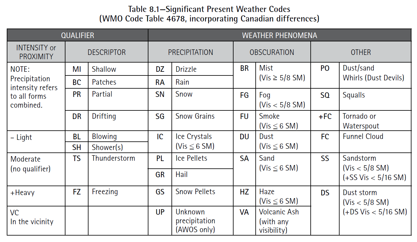
Present Weather:
| METAR CYHZ 271800Z CCB 15007G15KT 3/4SM R14/4000FT/D -RA BR BKN005 OVC010 05/M05 A3014 WS RWY 14 RMK SF5NS5 VIS NW 3/8 SLP218= Present weather consists of one or more weather phenomena and associated qualifier. Each weather phenomena can be either precipitation (ie. rain, snow, hail), obscuration (ie. mist, fog, haze), or other phenomena (ie. squalls, sand storm, tornado). Qualifiers precede the weather phenomena and show either intensity (ie. light, moderate, heavy), proximity (ie. in the vicinity), or descriptor (ie. blowing, drifting, patches). Each weather phenomena can have up to two qualifiers. The codes used are based on the World Meteorological Organisation (WMO) Codes Registry. You can click here to see the AIM table of WMO Code Table 4678, incorporating Canadian differences. In our example, there is light rain (-RA) and mist (BR). 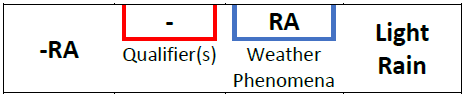 With light rain, “-” is the qualifier (intensity), “RA” is the weather phenomena (precipitation). 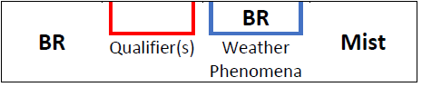 With mist, “BR” is the weather phenomena (obscuration). Intensity qualifiers are not used for obscurations as prevailing visibility would quantify the intensity. In the case of mist, proximity or descriptor qualifiers can be used such as “VS” (in the vicinity), or “BC” (patches). Here are some other examples: SHSN – moderate snow (SN) showers (SH) (when there is no + or – intensity it means moderate) BCFG – patchy (BC) fog (FG) -FZDZ – light (-) freezing (FZ) drizzle (DZ) |
Sky Conditions:
| METAR CYHZ 271800Z CCB 15007G15KT 3/4SM R14/4000FT/D -RA BR BKN005 OVC010 05/M05 A3014 WS RWY 14 RMK SF5NS5 VIS NW 3/8 SLP218= Sky conditions detail each observed cloud layer from the ground. The coverage area of a cloud layer is based on 8ths (oktas). If a layer covers 1/8 to 2/8 of the observed sky the layer is defined as few (FEW). A scattered (SCT) layer is 3/8 to 4/8. A broken (BKN) layer is 5/8 to less than 8/8. Overcast (OVC) is 8/8. When there is no cloud in the sky it is called sky clear, (SKC). Cloud heights are measured in 100s of feet to 10,000 feet, then 1,000s of feet thereafter. If the sky is obscured by something like fog and it is not possible to determine cloud layers, vertical visibility (VV) is reported in 100s of feet. If cumulonimbus (CB) or towering cumulus (TCU) clouds are present in a layer they will also be included following the layer height (OVC010TCU). In our example, there is a broken (BKN) layer at 500′ and an overcast (OVC) layer at 1,000′. |
Temperature and Dewpoint:
| METAR CYHZ 271800Z CCB 15007G15KT 3/4SM R14/4000FT/D -RA BR BKN005 OVC010 05/M05 A3014 WS RWY 14 RMK SF5NS5 VIS NW 3/8 SLP218= Temperature and dewpoint are indicated in Celsius with a forward slash between the two. Negative numbers are indicated with an “M” preceding the number. In our example, the temperature is 5 degrees Celsius and the dewpoint is negative 5 degrees Celsius. Note: A keen observer may notice that mist and low visibility in this METAR would be unlikely with a temperature and dewpoint spread of 10 degrees. This METAR is only for demonstration. |
Altimeter Setting:
| METAR CYHZ 271800Z CCB 15007G15KT 3/4SM R14/4000FT/D -RA BR BKN005 OVC010 05/M05 A3014 WS RWY 14 RMK SF5NS5 VIS NW 3/8 SLP218= In Canada and the United States altimeters are displayed in inches of mercury. The decimal place is not included but would be placed after the second digit. In our example, the altimeter is 30.14 inches of mercury. |
Wind Shear:
| METAR CYHZ 271800Z CCB 15007G15KT 3/4SM R14/4000FT/D -RA BR BKN005 OVC010 05/M05 A3014 WS RWY 14 RMK SF5NS5 VIS NW 3/8 SLP218= When wind shear is present on the approach or departure paths of a runway 1,500′ or less above the ground, WS is displayed along with the runway. In our example, there is wind shear on the approach or departure path of runway 14. |
Remarks:
| METAR CYHZ 271800Z CCB 15007G15KT 3/4SM R14/4000FT/D -RA BR BKN005 OVC010 05/M05 A3014 WS RWY 14 RMK SF5NS5 VIS NW 3/8 SLP218= In Canada, the remarks section includes additional details about weather observation, such as the types of clouds, general remarks, sea level pressure in hectopascals, and aerodrome density altitude. In our example, stratus fractus (SF) makes up 5/8th of the observed clouds, nimbostratus (NS) makes up 5/8th of the observed clouds, visibility (VIS) to the northwest (NW) is observed to be 3/8 statute mile, sea level pressure (SLP) is 1021.8 hectopascals. How does SLP218 become 1021.8 hectopascals? METAR hectopascals are measured from 950 – 1049. If you take the SLP and place either a 9 or 10 before the number and a decimal before the last digit, the outcome has to be in the range of 950 to 1049. |
Photo by Johannes Plenio on Unsplash
Related Posts
-

-

-
 AGA - Aerodromes / AIM - Aeronautical Information Manual / AIR - Airmanship / Aviation / COM - Communication, Navigation, and Surveillance / Flight Training / GEN - General / LRA - Licensing, Registration and Airworthiness / MAP - Aeronautical Charts and Publications / MET - Meteorology / NAT - North Atlantic Operations / NoAd / RAC - Rules of the Air and Air Traffic Services / SAR - Search and Recuse
Aeronautical Information Manual Explained
-

-

-