
Calculating Alternate Weather Requirements for Aerodromes with GFAs
Updated April 2020
When filing an IFR flight plan in Canada a pilot must indicate an alternate aerodrome, other than the destination aerodrome, that is suitable for landing if the destination becomes unavailable. A pilot must consider many factors when choosing an alternate, such as location, approaches, services available and weather. If the alternate aerodrome is not suitable as a destination, then it is likely a poor choice as an alternate.
The Canadian Aviation Regulations (CAR) state:
602.122 Except as otherwise authorized by the Minister in an air operator certificate or in a special authorization issued under subsection 604.05(2), no pilot-in-command shall operate an aircraft in IFR flight unless the IFR flight plan or IFR flight itinerary that has been filed for the flight under section 602.73 includes an alternate aerodrome having a landing area suitable for use by that aircraft.
and
602.123 No pilot-in-command of an aircraft shall include an alternate aerodrome in an IFR flight plan or IFR flight itinerary unless available weather information indicates that the ceiling and visibility at the alternate aerodrome will, at the expected time of arrival, be at or above the alternate aerodrome weather minima specified in the Canada Air Pilot.
When calculating alternate weather requirements for aerodromes served by TAFs the calculation requires an aerodrome to be served by a TAF. However, most aerodromes in Canada are not served by TAFs. This does not disqualify these aerodromes from being legal alternates on an IFR flight plan. Instead of using a TAF a pilot must refer to a graphical area forecast (GFA).
The Aeronautical Information Manual (AIM) RAC 3.13.1 states:
Aerodromes served with a GRAPHIC AREA FORECAST (GFA) may qualify as an alternate, provided the forecast weather contains:
(a) no cloud lower than 1 000 ft above the lowest usable HAT/HAA;
(b) no cumulonimbus; and
(c) a visibility that is not less than 3 mi.
Let’s look at an example to help understand these rules.
Example:
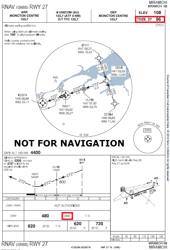
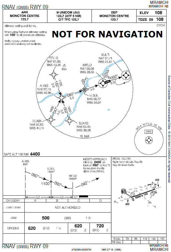
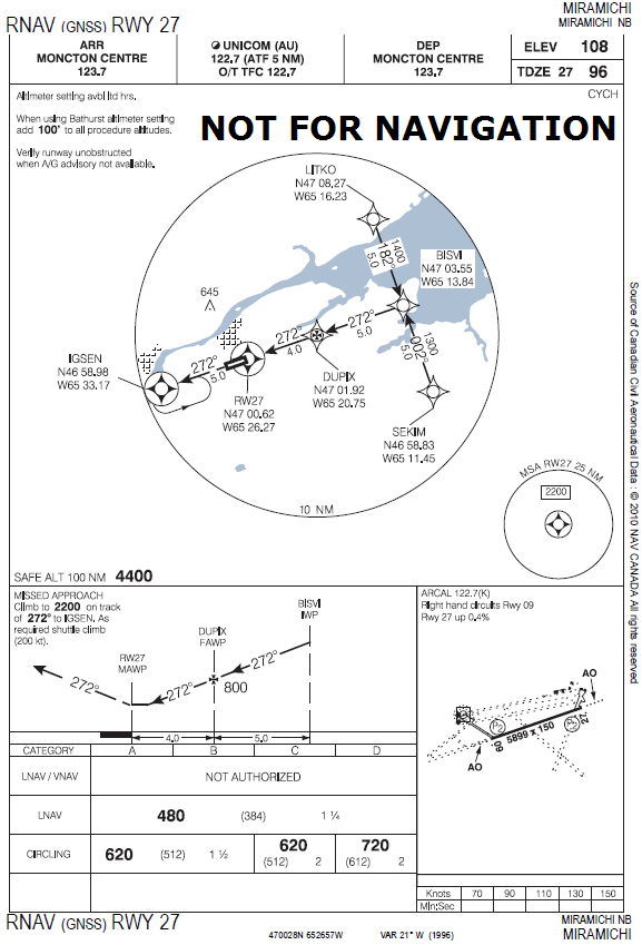
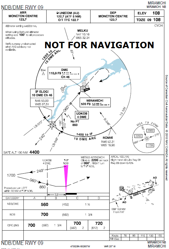
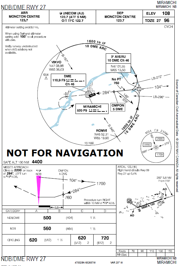
In this example, I will be using Miramichi, New Brunswick as my alternate. There are four approaches in Miramichi, RNAV 09, RNAV 27, NDB/DME 09, and NDB/DME 27. Base on a weather briefing, and wind conditions in nearby Bathurst and Moncton aerodromes, runway 27 will likely be the preferred runway. For added caution, I will include runway 09 while calculating the alternate minima.
- RNAV 27’s lowest HAT is 384′ AGL, which is rounded to 400′.
- NDB/DME 27’s lowest HAT is 404′ AGL, which is rounded to 400′.
- RNAV 09’s lowest HAT is 392′ AGL, which is rounded to 400′.
- NDB/DME 09’s lowest HAT is 452′ AGL, which is rounded to 500′.
As seen in my calculations above, the lowest usable HAT is 400′. I then apply the 1000′ rule as explained in the AIM, (400′ + 1000′ = 1400′ AGL). Since GFA altitudes are ASL, unless otherwise stated, I must add the touchdown zone elevation (TDZE) to this number. The TDZE for runway 27 is 96′, which is rounded to 100′, (1400′ AGL + 100′ = 1500′ ASL). I used the TDZE for runway 27 as this is likely the runway I would land on. You could also use the elevation of the aerodrome instead. When I look at my GFA I should see no cloud lower than 1500′ ASL at my ETA.
In summary, when I look at the GFA that covers Miramichi at my ETA I must see no forecasted cloud lower than 1500′ ASL, no cumulonimbus, and no visibility less than 3 miles.
You can see the approach plates for Miramichi here:
Below you can see the approach plate for RNAV 27 in Miramichi. The red boxes show where I got the TDZE and the HAT.
References:
- Canada Air Pilot – Published by Nav Canada and is available for purchase from many Canadian pilot supply stores and Nav Canada’s online store: http://products.navcanada.ca/
- Canadian Aviation Regulations – http://www.tc.gc.ca/eng/civilaviation/regserv/cars/menu.htm
- Aeronautical Information Manual – http://www.tc.gc.ca/eng/civilaviation/publications/tp14371-menu-3092.htm


Great!